Monumental nautical work with 24 volvelles
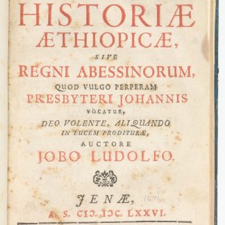
Arcano del Mare.
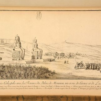
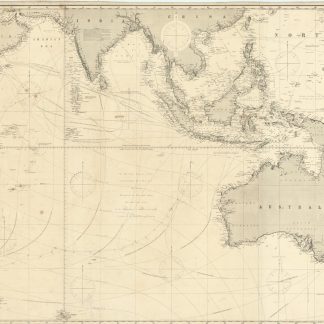
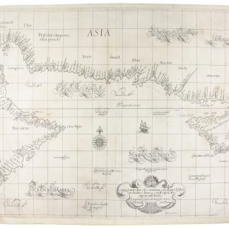
Large folio (500 x 560 mm). Book 1: (4), 30 pp., with engraved vignette of navigational instrument on printed title-page; double-page-sized engraved plate (facsimile of the Patent), 28 engraved plates including 24 volvelles: 21 with 29 moveable parts and 3 with strings. Book 2: 24 pp., 9 engraved plates with 6 volvelles (and 9 moveable parts), lacking the 15 engraved maps. Book 3: 25, (1) pp., 6 engraved plates. Book 4: 12 pp, 14 engraved plates (7 of which are double-page-sized). Book 5: 26 pp., 89 engraved plates, 36 with volvelles (with 61 moveable parts, another loose, and 5 strings), 4 double-page-sized. Without Book 6 (containing the Sea Charts). In all, 146 engraved plates, of which 66 show one or more volvelles, with 100 moveable parts. Full contemporary calf, ornate gilt spine with original red calf gilt title label. Includes Dudley's maritime map of the Indian Ocean, with the east of the Arabian Peninsula.
€ 85,000.00
Second (and arguably best) edition of Dudley’s landmark work on shipbuilding, nautical and astronomical instruments and navigation, all profusely illustrated with engravings. Book 1 deals with longitude; book 2 covers the errors which can be made when drawing sea-charts; book 3 deals with military and naval manoeuvres and exercise; book 4 describes the method of designing and building ships, on which this present work is the first scientific publication; book 5 is devoted to the art of navigation. Book 6, which is not present here, contains the sea atlas. The "Arcano del Mare (secrets of the sea) ... is an encyclopedia of everything connected with the sea from shipbuilding to navigation to cartography. This volume contains the text and volvelles for the sections devoted to navigation. It has been said that this volume is to the history of precision instruments of the seventeenth century what Peter Apian’s Astronomicum Caesareum was to the sixteenth" (Tomash & Williams).
The engraver employed for the immense task was Antonio Francesco Lucini, born in Florence in 1605. Lucini states in this second edition of 1661 that he worked for twelve years in a small Tuscan village, using 5,000 pounds of copper to make the plates. They represent the finest of Italian capabilities, the clarity of the engraving presenting an uncluttered image. Even the florid italic calligraphy, while fulfilling a purpose, is of the highest standard.
This is an example of the first volume only, containing books 1-5 of 6 but lacking the 15 general maps. The Library of Congress possesses a similar volume, and Phillips describes in detail the differing collations of Books 1-5. "The remainder of the work consists of writings to explain navigation, latitude and longitude, winds, tides, military and naval warfare, naval architecture, and instruments. Dudley illustrates his constructions and supplies working models with volvelles and pointers which can be moved for calculations [...] Up to about 1946, the Specola Museum in Florence possessed working wooden models of the instruments devised by Dudley. Unfortunately they were unwittingly destroyed in a building's incinerator during a fuel shortage" (Dilke).
Bookplate of the Institution of Naval Architects, Scott Library collection, recording presentation of the book by Mr. R. E. Scott, July 1930, on front pastedown. Hinges restored preserving original spine. Generally in very good condition.
Phillips 3428. Shirley, M.Dud-1b. Dilke, "Sir Robert Dudley's contribution to cartography", in: The Map Collector 19 (June 1982), pp. 10-14. The A. E. Nordenskiöld Collection 70. Tomash & Williams D69.